

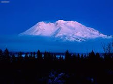
Black Butte looks impossible to climb but surprisingly, is a moderately graded trail can take you to the summit of this volcano where spectacular views await. It is located at the base of Mount Shasta in northern California about halfway between the towns of Weed and Mount Shasta City. This 6,325 foot plug dome is often confused for Mount Shasta by travelers along Interstate 5 when Shasta is covered in clouds. Black Butte formed at about the same time as Shastina, the "other" peak of Mount Shasta, about 9500 years ago and is a "cluster of dacite plug domes." The cooled lava rolled down the slopes forming the steep, rocky sides of Black Butte. Prior to the formation of Black Butte as we know it today, several domes of both Shastina and Black Butte exploded producing pyroclastic flows composed of ash, rocks, and gases. Weed and Mount Shasta City are built on these "block and ash" flows.
For any fans of John Muir, American naturalist, author, and early advocate of preservation of U.S. wilderness, you'll be interested to learn that the original name of "Black Butte" was Muir's Peak and it was the only thing he ever named after himself. John Muir loved this area and spent alot of time here and on Mt Shasta.
Climbing Black Butte is a favorite pasttime for many local residents and visitors. The 2 1/2 mile trail climbs nearly 2,000 feet from the trailhead to the summit. The road to the trailhead begins a short ways up Everitt Memorial Hwy. in Mount Shasta City, located to the south of Shasta Valley on I-5.
A 2.5-mile (4.0 km) long trail leads to the summit from a trailhead accessible by dirt roads off the Everitt Memorial Highway. The summit boasts an outstanding view of the southwest side of Shasta and Shastina, and on clear days Mount McLoughlin is easily visible 70 miles (113 km) to the north in Oregon.
No comments:
Post a Comment